Survey-grade LiDAR mapping.
Real-time localization.
Parietra builds the engine that turns raw LiDAR and other sensor data into repeatable, survey-quality maps — and tracks sensors inside those maps live. One core, shipped as Parietra Studio: Atlas, Explorer, and Arena.
- Deterministic — bit-identical rebuilds
- Ouster & Hesai native
- ROS 1 / ROS 2
- Runs on your Linux hardware
One engine. Multiple applications.
The same mapping and tracking core sits under every product — so a map captured in the field opens in the studio unchanged, and the tracker that localizes a robot is the one that tracks a camera.
Atlas
The mapping studio. Turn a recording or a live scan into a survey-quality map, then explore, clean, merge, export, and localize against it — all in one workflow.
Learn about Atlas Field · Parietra StudioExplorer
Field capture from your phone. A backpack sensor unit you drive from a browser — start a scan, watch the map build live as you walk, and hand it straight to Atlas.
Learn about Explorer Broadcast · Parietra StudioArena
Real-time, markerless camera tracking for aerial and cable-suspended broadcast cameras and for virtual production stages. Live 6-DoF pose inside a venue map, delivered to AR graphics at field rate.
Learn about ArenaBuilt to be trusted, not just to be fast.
Most SLAM stacks give you a different map every time you press run. Ours gives you the same one — and tells you when it couldn't. That discipline runs through everything from ingest to export.
-
01
Deterministic by default
Process the same dataset twice and get byte-identical output. Results are reproducible, auditable, and safe to compare across software versions. A GPU fast path is there when you want a preview in a hurry.
-
02
Live preview, survey-quality result
Scan live and watch the map build in real time, while the full-rate raw stream is recorded alongside. Post-processing that recording produces exactly the map a direct dataset build would.
-
03
Sensor-native ingest
Ouster OS-series and Hesai sensors, read directly. ROS 1 bags, ROS 2 MCAP, Ouster OSF and PCAP, and Parietra's own stream format — no conversion step.
-
04
Localization against frozen maps
Build the map once, then track inside it: robust relocalization, GNSS and wheel-odometry fusion, a clear tracking state machine, and ROS 1 / ROS 2 wrappers for integration.
-
05
Georeferenced to your control
Fuse GNSS during capture — or set ground control points on the finished map and adjust it to fit your site control, so exports land in the coordinate system your deliverables need.
-
06
One file per map
A map is a single file: the archive you keep, the thing you view and edit, and the source of every export — LAS, PLY, or a tracking map. There is never a second copy to drift out of sync.
-
07
Yours to run
Installs on a Linux workstation or a headless field computer. Your data stays on your hardware; there is no cloud dependency in the processing path.
Minutes in the field. Centimeter-level mapping and tracking accuracy.
In customer field tests, a plot that took a ~45-minute terrestrial-scanner session — stations, targets, teardown — walks in about 5 minutes as a mobile scan. That trade is only worth making if you know exactly what it costs in accuracy, so we measure it on every release: public benchmark sequences with surveyed ground truth, processed with the shipping default configuration, no per-sequence tuning.
Typical plot capture, terrestrial-scanner session vs a walked mobile scan, in customer field tests.
HILTI '21 Basement 3 — ahead of all five podium teams' 4.2–6.2 cm on the same sequence.
Best sequence — HILTI '21 Construction Site 1.
Variance across re-runs. Every number below is from a deterministic build that reproduces byte-identically.
| Sequence | Atlas ATE RMSE | Top 5 · notes |
|---|---|---|
| Basement 3 | 3.62 cm | 4.2–6.2 cm — the five podium teams on this sequence¹ |
| Basement 4 | 3.96 cm | — |
| Campus 1 | 7.63 cm | — |
| Campus 2 | 5.80 cm | — |
| Construction Site 1 | 2.48 cm | — |
| Construction Site 2 | 10.03 cm | — |
| LAB | 3.77 cm | — |
| Sequence | Atlas ATE RMSE | Top published |
|---|---|---|
| quad — easy | 6.77 cm | 7.0 cm (FAST-LIO) |
| quad — medium | 6.11 cm | 5.6–6.4 cm |
| quad — hard | 5.04 cm | 4.6–8.4 cm; others diverge (DLIO 266 cm) |
Protocol: SE(3) Umeyama-aligned absolute trajectory error (RMSE) against released ground truth — the literature-standard metric — measured on release 0.9.11 (August 2026), one shipping configuration for every row, duplicate runs byte-identical.
¹ Parietra did not enter the HILTI challenges; every Atlas figure on this page is self-measured on the public datasets against released ground truth. The challenges scored their entrants on surveyed control points (a points system, not trajectory ATE), so our figures are not challenge scores. Basement 3 podium ATE values are read from the official leaderboard error plots (±0.3 cm). The 2021 winner averaged 9.3 cm over the full 12-sequence set. The table lists seven of the eight released-ground-truth sequences we run; the eighth, an aggressive drone-flight arena sequence outside the handheld envelope, measured 24.1 cm. Source: hilti-challenge.com.
² Newer College published figures are from the cited papers (COIN-LIO et al.); third-party reproductions of the same methods vary between papers. Source: Oxford Robotics Institute, Newer College multi-camera extension.
Field-time comparison from customer field tests of backpack capture against a terrestrial laser scanner workflow, including setup, alignment targets, station moves, and teardown. Numbers are self-measured on public data; ask us for the full per-release benchmark records.
Where a map you can rely on matters.
Forestry research
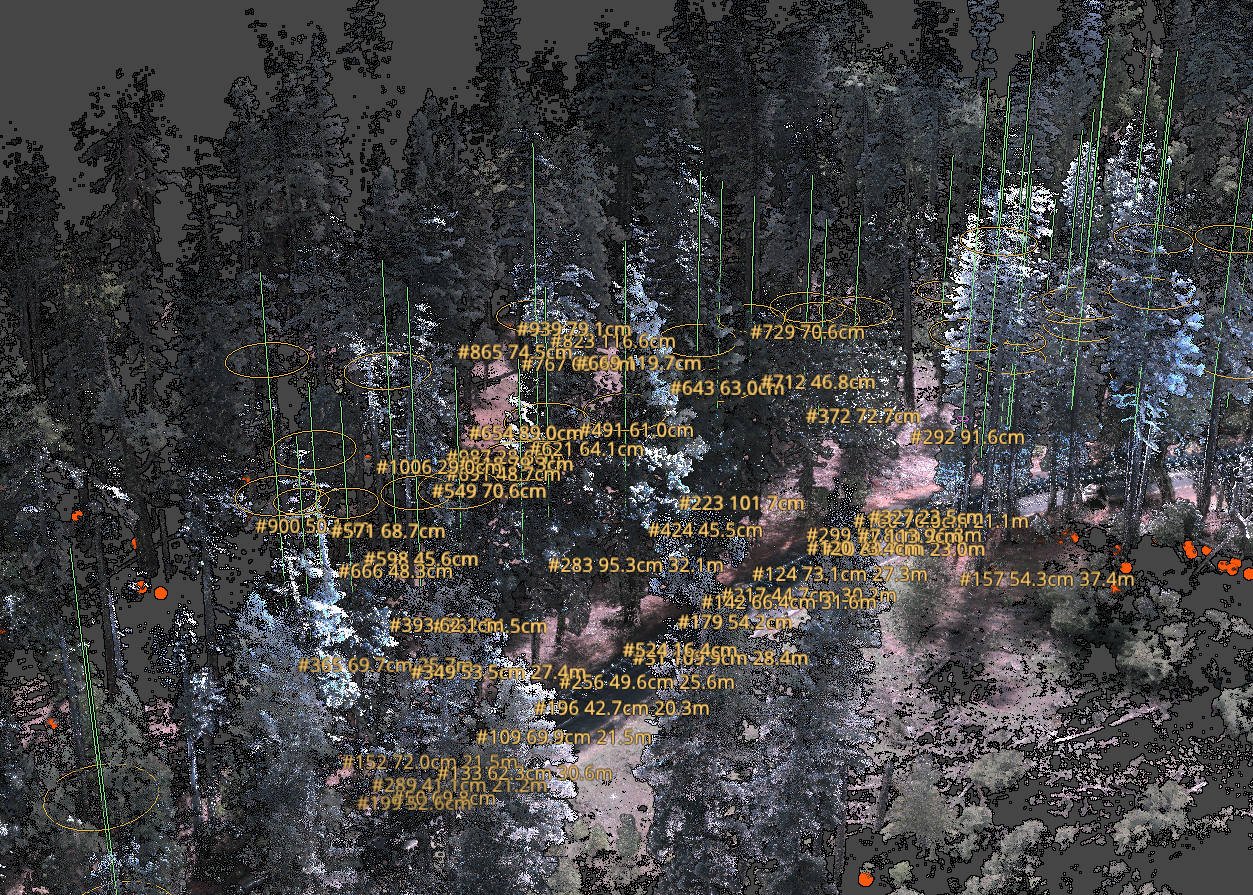
Walk a plot with a handheld or backpack scanner and get a clean, deskewed cloud of raw points — the input tree-metric tools want. Stem detection and DBH estimation are built in.
Surveying & mapping
Mobile mapping of sites, interiors, and infrastructure with repeatable results. Merge sessions, correct trajectories, classify, and export PLY or LAS into your existing pipeline.
Robotics & autonomy
Map once, localize forever. Real-time pose against a frozen map with GNSS and odometry fusion, a tracking health state, and ROS 1 / ROS 2 nodes over the same core.
Live broadcast & virtual production
Markerless camera tracking for aerial and cable-cam rigs and for virtual production stages: a LiDAR map of the venue or stage replaces markers and constellations, sets up in minutes, and delivers to AR and virtual-set graphics in the format your pipeline expects.
A spatial-intelligence software company.
The parietal lobe for digital systems. In the brain, the parietal lobe turns raw senses into a sense of where things are. Parietra does that for machines: raw LiDAR and other sensor data become a map and a position they can act on.
Parietra builds the mapping and localization engine behind Atlas, Explorer, and Arena. We are a small team of SLAM and systems engineers who care about the unglamorous things — reproducibility, provenance, sensor timing, and software that behaves the same in the field as it did on the bench.
How we work
Every change is gated on a benchmark suite before it ships. Accuracy claims are quoted as measured bands, not single lucky runs. If it isn't deterministic, it isn't the default.
Licensing
Studio — Atlas, Explorer, and Arena — is licensed per machine, with the features you purchase. Time-limited evaluation licenses are available for qualified teams.
Tell us about your use case and requirements.
Whether it's a forest plot, a survey vehicle, a robot fleet, an office or a warehouse, we'd like to hear what you are mapping. We can guide you on whether Atlas is the right solution for you.